Cool Stuff with Geo Data for Your Local Website
So here are a few cool geo data things you can do for a local website.
Geo-Meta Tags
Now I’ve been adding geo meta tags to websites for some time now. An easy tool to use to generate your geo-location meta tags can be found at mygeolocation.com. Simply navigate the map to pinpoint your location then click the Geo-Meta Tags button. Copy and paste those tags into the head section of your web page.
You can also then submit your website and location to GeoURL here.
Google Maps - My Maps
In Google Maps you can create public maps. You can use this map as a feature on the “about us” page or “service area” page of your website. Or just have fun with it like this one I made.
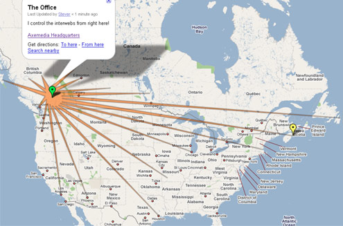
Create a placemark and then you can add text in the pop-up balloon that appears when the placemark is clicked. You can add html inside the balloon, so include a link to your site and maybe an image of your logo or something.
You can draw lines and create polygon shapes too.
I went a little overboard for this example but for a local business you could simply leave it as a placemark only, or add a polygon of the area you service.
KML Geo Data Files
Now this is new and cool. You can create a similar map to your Google My Maps as an XML file in KMS format. Done right you can open this file in any geo-mapping service, like Google Earth, and you will see your map, placemarks and balloon text.
Now I could not find any easy online automated tools for creating a detailed kml file. But for a basic one with points you can again use the tool at mygeolocation.com. There is another button to generate KML data.
You can also use Google Earth to create your KML files. Add a place marker where you want it. In the pop-up give it a title. You can then write HTML into the description field. When your done find that point you just made in your My Places menu on the left. Right click on it in My Places and click copy. When you go to paste it into a basic text editor, like Notepad, it pastes the kml source code. Save that text file with the extension .kml and presto, you have your KML file.
You can see my KML file here. I used Google Earth to generate that.
If you are a subscriber to Google Earth Plus you can create polygons and lines in there too. I’m not ![]() But i see its only $20 per year for a subscription. Looks like I know where i’m spending $20 soon.
But i see its only $20 per year for a subscription. Looks like I know where i’m spending $20 soon.
For even more advanced uses of KML data you can see all the tags available and how they work here in Google’s KML Reference available here.
Add that KML File to Your Sitemap!
Like mentioned in Mike ’s post, add that KML file to your sitemap to let Google crawl your geo-data. Here’s how to add your geo data to your sitemap.
It appears to build a lot more trust with Google if you have one of these geo-data files so its certainly worthwhile.
Oh yeah, and don’t forget to link to your website from within your description balloon. It may send a little traffic too.


DoFollow links available for frequent commentors.
4 Comments to “Cool Stuff with Geo Data for Your Local Website”
Leave a Comment
RSS Feed
The Topics
- I’m Such a Nerd - Now a Wine Nerd
- An Ode to a Very Special Little Rescue Dog
- Centering a Div in IE9 Using margin:auto
- Playing with HTML5 for First Time
- My Wife is a Food Blogger
- Designing and Coding a Mobile Version of your Website
- A CSS Sticky Footer that Works in 2009 (Chrome too) (340)
- New iGoogle with Left Nav Bar is the SUCK! (194)
- My Cool Ass CB750 Cafe Racer (104)
- Centering a Div in IE8 Using margin:auto (15)
- The State of Local Search in Canada (14)


Recent Stuff

There is some very easy to use and powerful desktop software to create various and geo-tagged photo files in KML, KMZ format.
On my Mac I use HoudahGeo. can shoot a bunch of photos, geo tag them, create content for the pin and import them into MyMaps or Flickr or Panoramio. It will work with GPS devices or allow manual entry of geo info.
Thus the photo and its location become the basis for a Map and an automated workflow.
I am sure there must be similar PC based products.
Mike
You can also create your map in Google MyMaps - and then export it the KML and pull it into your website
I’ve tried that too Dave. But if you look at that KML file that is generated it’s mostly gibberish code that only GMaps and Earth can decipher. Probably referencing to where they are storing that actual data on the Google servers.
This works fine and is an easy way to put KML maps onto your own site but I’m not sure how well those files end up being crawled and indexed by Google bot? Compared to a full KML file where all your location and text data is right there in XML format, and thus is usable in other mapping systems outside of GMaps and GEarth.
[…] few weeks ago I posted a few neat things you can do with geo-data for your website and delved into adding KML geo files to your website. Well, I noticed one small problem. When […]